
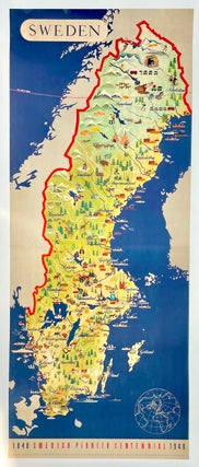
Swedish Centennial Pictorial Map (1948)
This 1948 Sweden Centennial pictorial map is almost 6 feet tall! Celebrating 100 years of the Scandinavian nation and delightfully illustrated, the map highlights regional names and cities, geological features, resources and commercial industries, various recreational activities, along with images of ships, sailboats, farming, mining, skiers, hikers, hunters, wildlife, and more. Published by the Swedish Institute and Swedish Tourist Traffic Association. With the credits running along the bottom: "Design: O. Laurelius. Printed in Sweden by Ivar Haeggstroms Boktryckeri AB. Stockholm 1948". Professionally cleaned, restored and linen-backed on canvas.
Condition: Very.....
Item #1478